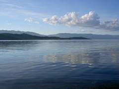
About Baikal Baikal is the deepest freshwater lake in the world. Is is located in the centre of Asian continent, on the South of Eastern Siberia in latitude 55 °46, 4 – 51° 27,5 North. East and North parts of the lake are officially belonged to Buryatia Republic, the West one with Olkhon Island forms a part of Irkutsk region.
 Baikal Parameters: Baikal Parameters:
a length – 636 km
a width:
the greatest – 79,5 km
the least – 27 km
coastline length – 2000 km
maximum depth – 1637 km (at the East coast of Olkhon Island)
The Baikal Colux consists of three hollows (the north, the middle, the south), detached with submarine hills –rapids (the Selenginsky separates the south hollow from the middle, Academic submarin range rising over waterline on 210 m as the Ushkany Islands serves as boundary between north and middle hollows). The smallest hollow is the north, its maximum depth is 1419 m; the deepest is the middle, its depth is 1637 m.
Water mirror square is 31500 (the 8th place in the world).
Catchment area square is 588000 km.
 Water Mass Volume is 23000 m³. It’s 92 as many as in the Azov Sea, 4,3 as many as in the White Sea. And the same water mass is in the 5 Great American Lakes. It’s 1/5 of world freshwater reserve. Water Mass Volume is 23000 m³. It’s 92 as many as in the Azov Sea, 4,3 as many as in the White Sea. And the same water mass is in the 5 Great American Lakes. It’s 1/5 of world freshwater reserve.
The height above the Baltic Sea is 456 m. The Federal law of the RF (from 26.03.2001) prescribes “to set maximum and minimum Baikal water lines, accordingly 457,0 m and 456,0 m, in the usage of its water resourses at industry and other activities”.
Under data of Cherkesky (1886), near 336 rivers and streams flow into Baikal. In 1964 V.M.Boyarsky made a calculation of Baikal rivers according to topography maps. Under his data, approximately 544 waterways (permanent and temporal) flow into Baikal, as 230 from the Western coast (40%) and 324 from the Eastern coast (60%).
Baikal is edged with mountains. It’s mountain relief of Baikal region that determines coast traits. Whole of Baikal coastlines are separated with bays and capes. In 1886Yan Chersky numbered 174 capes, 101 of which are located on the North-Western coast, while 73 belong to the South-Eastern coastline.
Within capes there are bays, the biggest ones are Barguzinsky – 727 km² (it’s the deepest – 1284 m), Chivyrkujsky – 270 km², Proval – 197 km², Posolsky – 35 km², Cherkalov – 20 km², Mukhor – 16 km.
Th characteristic of Baikal water area is sorys (shallow bays) existence.
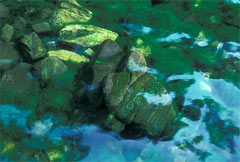
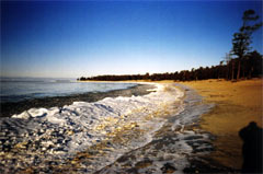 South and Middle parts of Western coast right up to the Olkhonskye Vorota Strait, as well as, Eastern coast of Olkhon Island are mainly formed with sharp, often rock coasts which are divided by wide river piains and small streams. Coasts are covered with stones, the exception is Peschanaya bay and near located bays. There is the most famous tourist base “Peschanaya Bay”. South and Middle parts of Western coast right up to the Olkhonskye Vorota Strait, as well as, Eastern coast of Olkhon Island are mainly formed with sharp, often rock coasts which are divided by wide river piains and small streams. Coasts are covered with stones, the exception is Peschanaya bay and near located bays. There is the most famous tourist base “Peschanaya Bay”.
The Olhonskie Vorota Strait leads to the Small Sea, big isolated area between Western Baikal coast and biggest island – Olkhon. The Small Sea is one of unique Baikal regions thanks to climate conditions. Comfortable for yacht parking bays on the South, rare rains, rather warm water, rock-taiga and steep landscapes, as well as, accessibility make this place very popular but vulnerable.
Olkhon islands are integral part of Baikal. Under latest data, there are near 35 rather stable islands.
CD-Disc "Flora & Fauna" |